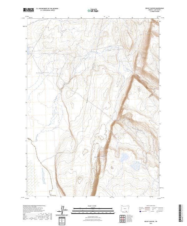
2024 Map of Rocky Canyon
USGS Topo · Published 2024About this map
Guano Rim and the dramatic drop into Guano Valley dominate this high-desert landscape in Lake County. The terrain is defined by its seasonal hydrology, where Sage Hen Creek and its namesake Sage Hen Canyon cut through the volcanic plateaus. A remote corridor for travel, Beattys Butte Rd serves as the primary artery through this arid expanse, passing the curious landmark of Wagonslide near the rim. This 2024 survey documents a region of stark topographical contrasts, where the flat basin containing Shirk Lake sits in the shadow of the deeply incised Rocky Canyon. The map provides a detailed view of the township and range grid system across these public lands, illustrating how drainage patterns dictate the limited human footprint in this corner of the Great Basin.
Find a feature on this map
14 named features on this map. Tap any name to fly to it.
Don’t see what you’re looking for? This feature index may not catch every label — zoom into the map to look around manually.
Map Details
Editions of this 2024 Rocky Canyon Map
This is the sole edition of this map. No revisions or reprints were ever made.
Other maps of this area

1955 · Adel
USGS Topo · 1:250,000

1957 · Adel
USGS Topo · 1:250,000

1958 · Adel
USGS Topo · 1:250,000

1962 · Adel
USGS Topo · 1:250,000

1967 · Alger Lake
USGS Topo · 1:24,000
1968 · Piute Reservoir
USGS Topo · 1:24,000

1968 · Guano Lake
USGS Topo · 1:24,000

1971 · Mahogany Butte
USGS Topo · 1:24,000
1971 · Rocky Canyon
USGS Topo · 1:24,000
1971 · Sage Hen Flats
USGS Topo · 1:24,000