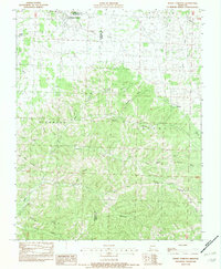
1982 Map of Rocky Comfort
USGS Topo · Published 1982About this map
Rocky Comfort serves as the primary focal point of this rural Ozark landscape, situated near the intersection of the Newton and McDonald County line. The terrain is defined by a dense network of timbered ridges and named hollows, reflecting a topography that heavily influenced early Missouri settlement patterns. Deep drainages such as Layton Hollow, Chairbottom Hollow, and Reed Springs Hollow provide a detailed look at the area's natural drainage into Indian Creek and Shoal Creek. Further south, the map illustrates the transition into Barry County near the small community of Ridgley. Notable landmarks include Christian Spring and a local Cem, providing valuable points of interest for genealogists tracing family histories in the townships of Richwood, Liberty, and Franklin.
Find a feature on this map
32 named features on this map. Tap any name to fly to it.
Don’t see what you’re looking for? This feature index may not catch every label — zoom into the map to look around manually.
Map Details
Editions of this 1982 Rocky Comfort Map
This is the sole edition of this map. No revisions or reprints were ever made.
Other maps of this area

1937 · Cassville
USGS Topo · 1:48,000

1941 · Rocky Comfort
USGS Topo · 1:62,500

1943 · Ritchey
USGS Topo · 1:62,500

1943 · Monett
USGS Topo · 1:62,500

1943 · Rocky Comfort
USGS Topo · 1:62,500

1944 · Cassville
USGS Topo · 1:62,500

1945 · Harrison
USGS Topo · 1:250,000

1949 · Harrison
USGS Topo · 1:250,000

1954 · Harrison
USGS Topo · 1:250,000

1954 · Tulsa
USGS Topo · 1:250,000