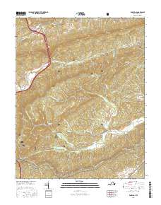
2016 Map of Rocky Gap
USGS Topo · Published 2016About this map
Rocky Gap and the surrounding highlands of the Jefferson National Forest define this corner of the Appalachian landscape. The terrain is marked by high ridges like Rich Mtn and Wolf Creek Mtn, which funnel development into narrow valleys along Wolf Creek and Kimberling Cr. In the south, the Appalachian National Scenic Trail winds across Brushy Mtn, passing near the small community of Point Pleasant. Local history is preserved in the valley floors at sites like Hoges Chapel Methodist Cem and the Tuggle Cem. The distribution of settlements such as Kimberling and Pumpkin Center reflects a long-standing reliance on the creek bottoms for transport and agriculture, while the gap itself remains a vital corridor for travel between the ridges of southwest Virginia.
Find a feature on this map
32 named features on this map. Tap any name to fly to it.
Don’t see what you’re looking for? This feature index may not catch every label — zoom into the map to look around manually.
Map Details
Editions of this 2016 Rocky Gap Map
This is the sole edition of this map. No revisions or reprints were ever made.
Other maps of this area

1887 · Pocahontas
USGS Topo · 1:125,000

1890 · Dublin
USGS Topo · 1:125,000

1891 · Pocahontas
USGS Topo · 1:125,000

1891 · Dublin
USGS Topo · 1:125,000

1894 · Pocahontas
USGS Topo · 1:125,000

1895 · Pocahontas
USGS Topo · 1:125,000

1913 · Peterstown
USGS Topo · 1:48,000

1913 · Bluefield
USGS Topo · 1:48,000

1916 · Bluefield
USGS Topo · 1:62,500

1916 · Peterstown
USGS Topo · 1:62,500