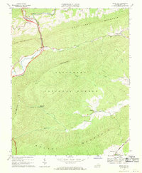
1968 Map of Rocky Gap
USGS Topo · Published 1970About this map
Wolf Creek carves its way through the mountain passes of Bland County, anchoring a landscape where small settlements like Rocky Gap and South Gap sit at the confluence of valley floors and steep ridges. This late-1960s survey illustrates a region defined by its water sources and high peaks, including Rich Mountain and Wolf Creek Mountain. A significant portion of the terrain is managed as part of the Jefferson National Forest, with topographic details showing the steep grades of Hogback and Brushy Mountain. Local history and genealogy are preserved in labels for family-named sites such as Tuggle Cem and Hoges Chapel Cem. Farther south, the community of Kimberling and the nearby Kimberling Springs highlight the importance of natural springs in the area’s early development, while a Proposed Location for a future highway corridor signals the coming modernization of this Appalachian corridor.
Find a feature on this map
28 named features on this map. Tap any name to fly to it.
Don’t see what you’re looking for? This feature index may not catch every label — zoom into the map to look around manually.
Map Details
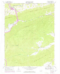
Editions of this 1968 Rocky Gap Map
2 editions found
Other maps of this area

1887 · Pocahontas
USGS Topo · 1:125,000

1890 · Dublin
USGS Topo · 1:125,000

1891 · Pocahontas
USGS Topo · 1:125,000

1891 · Dublin
USGS Topo · 1:125,000

1894 · Pocahontas
USGS Topo · 1:125,000

1895 · Pocahontas
USGS Topo · 1:125,000

1913 · Peterstown
USGS Topo · 1:48,000

1913 · Bluefield
USGS Topo · 1:48,000

1916 · Bluefield
USGS Topo · 1:62,500

1916 · Peterstown
USGS Topo · 1:62,500