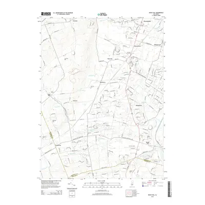
2014 Map of Rocky Hill
USGS Topo · Published 2014About this map
Sourland Mtn dominates the western landscape of this Somerset County region, providing a high-elevation backdrop to the network of streams and colonial-era settlements below. The map documents the intricate water system of the area, where Rock Brook, Roaring Brook, and Beden Brook carve through the terrain. In the southeast, the historic Delaware and Raritan Canal runs parallel to the Millstone River, marking a corridor of early industrial transport that contrasts with the 21st-century infrastructure of the Princeton airport. Smaller hamlets like Blawenburg, Dutchtown, and Stoutsburg remain distinct points of interest, often centered around long-standing landmarks such as the Stoutsburg Cem or the Harlingen Reformed Cem. The transition from the rugged slopes of Pheasant Hill to the structured residential clusters near Hillsborough illustrates the modern suburban evolution atop a deeply rooted agricultural and hydrological foundation.
Find a feature on this map
188 named features on this map. Tap any name to fly to it.
Don’t see what you’re looking for? This feature index may not catch every label — zoom into the map to look around manually.
Map Details
Editions of this 2014 Rocky Hill Map
This is the sole edition of this map. No revisions or reprints were ever made.
Other maps of this area

1888 · Princeton
USGS Topo · 1:62,500

1890 · High Bridge
USGS Topo · 1:62,500

1890 · Lambertville
USGS Topo · 1:62,500

1891 · Somerville
USGS Topo · 1:62,500

1891 · Lambertville
USGS Topo · 1:62,500

1893 · Somerville
USGS Topo · 1:62,500

1894 · Princeton
USGS Topo · 1:62,500

1894 · Lambertville
USGS Topo · 1:62,500

1898 · High Bridge
USGS Topo · 1:62,500

1898 · Somerville
USGS Topo · 1:62,500
Featured Places
- Franklin Township, NJ
- Hillsborough Township, NJ
- Montgomery Township, NJ
- Hopewell Township, NJ
- Princeton, NJ