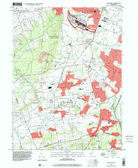
1995 Map of Rocky Hill
USGS Topo · Published 2000About this map
Sourland Mountain dominates the western landscape of this mid-1990s survey, a prominent rise overlooking a network of agricultural and institutional lands in central New Jersey. The industrial footprint of the GSA Belle Meade Depot and the sprawling campus of the North Princeton Developmental Center reflect the region's historical reliance on large-scale government and state facilities. Transportation is a central theme, as the Millstone River and the parallel D & R Canal State Park border the borough of Rocky Hill, while the Princeton Airport and various rail lines provide modern and historical transit corridors through Hillsborough and Montgomery Township. Genealogists may find value in the many well-preserved burial grounds and religious sites, such as the Blawenburg Cem and the Harlingen Reformed Ch, which serve as anchors for established communities like Skillman and Belle Mead.
Find a feature on this map
83 named features on this map. Tap any name to fly to it.
Don’t see what you’re looking for? This feature index may not catch every label — zoom into the map to look around manually.
Map Details
Editions of this 1995 Rocky Hill Map
This is the sole edition of this map. No revisions or reprints were ever made.
Other maps of this area

1888 · Princeton
USGS Topo · 1:62,500

1890 · High Bridge
USGS Topo · 1:62,500

1890 · Lambertville
USGS Topo · 1:62,500

1891 · Somerville
USGS Topo · 1:62,500

1891 · Lambertville
USGS Topo · 1:62,500

1893 · Somerville
USGS Topo · 1:62,500

1894 · Princeton
USGS Topo · 1:62,500

1894 · Lambertville
USGS Topo · 1:62,500

1898 · High Bridge
USGS Topo · 1:62,500

1898 · Somerville
USGS Topo · 1:62,500
Featured Places
- Franklin Township, NJ
- Hillsborough Township, NJ
- Montgomery Township, NJ
- Hopewell Township, NJ
- Princeton, NJ