
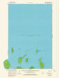
1963 Map of Rocky Island
USGS Topo · Published 1965About this map
Apostle Islands emerge from the deep waters of Lake Superior in this mid-century maritime survey within La Pointe Twp. The map documents a cluster of landmasses including Devils Island, which features a prominent Light and Radio Tower at its northern point to guide ships through the nearby Devils Island Shoal. This era reflects a period of limited development on these remote outposts, with a solitary Landing Strip on South Twin Island providing one of the few modern transport links to the mainland. Navigational soundings throughout the lake reveal the submerged topography surrounding Bear Island, Rocky Island, and Cat Island, highlighting the complex underwater environment that has long challenged Lake Superior mariners. Other named features like Ironwood Island and Otter Island appear in their mid-twentieth-century state, showing the geographic relationships between these isolated landforms before modern park designations.
Find a feature on this map
15 named features on this map. Tap any name to fly to it.
Don’t see what you’re looking for? This feature index may not catch every label — zoom into the map to look around manually.
Map Details
Editions of this 1963 Rocky Island Map
2 editions found
Other maps of this area

1941 · Bayfield
USGS Topo · 1:48,000

1946 · Bayfield
USGS Topo · 1:48,000

1953 · Ashland
USGS Topo · 1:250,000

1954 · Two Harbors
USGS Topo · 1:250,000

1957 · Two Harbors
USGS Topo · 1:250,000

1958 · Ashland
USGS Topo · 1:250,000

1958 · Two Harbors
USGS Topo · 1:250,000
1963 · Outer Island
USGS Topo · 1:62,500

1963 · Cat Island
USGS Topo · 1:24,000

1963 · Michigan Island
USGS Topo · 1:24,000