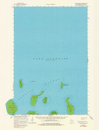
1963 Map of Rocky Island
USGS Topo · Published 1980About this map
Apostle Islands dot the waters of Lake Superior in this mid-century survey of the La Pointe Twp region. The map focuses on the northernmost reaches of the archipelago, where the landscape is defined by secluded islands rather than mainland settlements. Notable navigational markers include a radio tower and light on Devils Island, which stands as the northern sentinel above the Devils Island Shoal.
Find a feature on this map
14 named features on this map. Tap any name to fly to it.
Don’t see what you’re looking for? This feature index may not catch every label — zoom into the map to look around manually.
Map Details
Editions of this 1963 Rocky Island Map
2 editions found

Other maps of this area

1941 · Bayfield
USGS Topo · 1:48,000

1946 · Bayfield
USGS Topo · 1:48,000

1953 · Ashland
USGS Topo · 1:250,000

1954 · Two Harbors
USGS Topo · 1:250,000

1957 · Two Harbors
USGS Topo · 1:250,000

1958 · Ashland
USGS Topo · 1:250,000

1958 · Two Harbors
USGS Topo · 1:250,000
1963 · Outer Island
USGS Topo · 1:62,500

1963 · Cat Island
USGS Topo · 1:24,000

1963 · Michigan Island
USGS Topo · 1:24,000