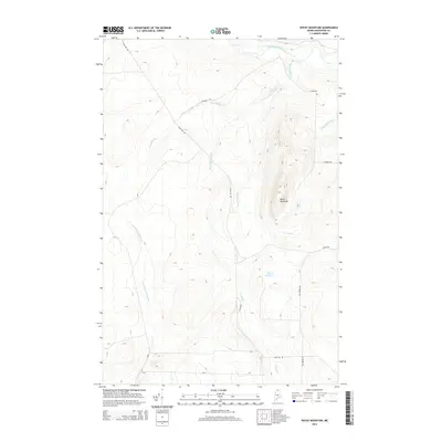
2014 Map of Rocky Mountain
USGS Topo · Published 2014About this map
Rocky Mountain dominates this portion of northern Aroostook County, serving as a prominent high point for a landscape defined by an intricate network of waterways. The northern boundary is marked by the Little Black River, which collects drainage from several tributaries including Whitney Brook and the W Br Chase Brook. This area is characterized by heavy logging and forestry infrastructure, evidenced by a grid of named timber roads such as Camp 106 Rd and Dickey Rd that navigate the high ridges and valley floors. To the south, the terrain descends toward Fox Pond and the headwaters of Fox Brook, while the western slopes feed into the E Br Pocwock Stream. The map reveals a working forest landscape where industrial access routes like E Branch Rd and Fox Brook Rd provide the only passage through the dense northern Maine woods.
Find a feature on this map
15 named features on this map. Tap any name to fly to it.
Don’t see what you’re looking for? This feature index may not catch every label — zoom into the map to look around manually.
Map Details
Editions of this 2014 Rocky Mountain Map
This is the sole edition of this map. No revisions or reprints were ever made.
Other maps of this area

1930 · Allagash
USGS Topo · 1:48,000

1933 · Allagash
USGS Topo · 1:62,500

1955 · Rocky Mountain
USGS Topo · 1:62,500

1955 · Rocky Brook
USGS Topo · 1:62,500

1955 · Beau Lake
USGS Topo · 1:62,500

1962 · Edmundston
USGS Topo · 1:250,000
1986 · Big Rapids
USGS Topo · 1:24,000
1987 · Johnson Brook Mountain
USGS Topo · 1:24,000

1987 · Hafey Pond
USGS Topo · 1:24,000
1987 · Rocky Mountain SW
USGS Topo · 1:24,000