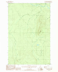
1987 Map of Rocky Mountain
USGS Topo · Published 1987About this map
Little Black River flows across the northern edge of this remote Maine borderland, which was documented by the USGS in the late 1980s. The landscape is defined by its complex drainage network, including the West Branch Whitney Brook and East Branch Pocwock Stream, which carve through the dense woodlands. The most prominent terrain feature is the elevation at Rocky Mountain, standing watch over the surrounding timberlands and the quiet waters of Fox Pond. Aside from a Gravel Pit near the river, the map shows very little industrial or residential development, instead highlighting the precise surveying of township boundaries such as T 18 R 13 W E L S. This survey captures a specific moment in the management of the North Maine Woods, where unimproved roads and logging trails provide the only passage through the drainages of Rocky Brook and Chase Brook.
Find a feature on this map
14 named features on this map. Tap any name to fly to it.
Don’t see what you’re looking for? This feature index may not catch every label — zoom into the map to look around manually.
Map Details
Editions of this 1987 Rocky Mountain Map
This is the sole edition of this map. No revisions or reprints were ever made.
Other maps of this area

1930 · Allagash
USGS Topo · 1:48,000

1933 · Allagash
USGS Topo · 1:62,500

1955 · Rocky Mountain
USGS Topo · 1:62,500

1955 · Rocky Brook
USGS Topo · 1:62,500

1955 · Beau Lake
USGS Topo · 1:62,500

1962 · Edmundston
USGS Topo · 1:250,000
1986 · Big Rapids
USGS Topo · 1:24,000
1987 · Johnson Brook Mountain
USGS Topo · 1:24,000

1987 · Hafey Pond
USGS Topo · 1:24,000
1987 · Rocky Mountain SW
USGS Topo · 1:24,000