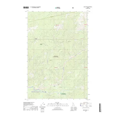
2020 Map of Rocky Point
USGS Topo · Published 2020About this map
Clearwater National Forest dominates this section of north-central Idaho, where the Lochsa River and Crooked Fork converge. The landscape is defined by the high-elevation ridges of Rocky Point and Parachute Hill, accessed by a network of forest service routes including the historic Lolo Motor Way and Measure Rd. The southern portion of the map highlights the Middle Fork Clearwater Wild and Scenic River corridor, a critical area for conservation and recreation.
Find a feature on this map
39 named features on this map. Tap any name to fly to it.
Don’t see what you’re looking for? This feature index may not catch every label — zoom into the map to look around manually.
Map Details
Editions of this 2020 Rocky Point Map
This is the sole edition of this map. No revisions or reprints were ever made.
Other maps of this area

1911 · Lolo
USGS Topo · 1:250,000

1913 · Lolo
USGS Topo · 1:250,000

1956 · Hamilton
USGS Topo · 1:250,000

1959 · Hamilton
USGS Topo · 1:250,000

1960 · Hamilton
USGS Topo · 1:250,000

1964 · Hamilton
USGS Topo · 1:250,000

1964 · Lolo Hot Springs
USGS Topo · 1:24,000

1964 · Rocky Point
USGS Topo · 1:24,000

1964 · Roundtop
USGS Topo · 1:24,000
1964 · Granite Pass
USGS Topo · 1:24,000