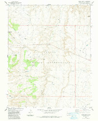
1983 Map of Rocky Point
USGS Topo · Published 1984About this map
Navajo Indian Reservation lands in northwestern New Mexico are defined by a complex network of arid drainage systems and high desert landforms in this early 1980s survey. The landscape is carved by seasonal watercourses like Beclabito Wash and Red Wash, while distinctive geological features such as Black Rock Point, Bruised Ridge, and Rock Pile Mesa rise above the surrounding terrain.
Find a feature on this map
29 named features on this map. Tap any name to fly to it.
Don’t see what you’re looking for? This feature index may not catch every label — zoom into the map to look around manually.
Map Details
Editions of this 1983 Rocky Point Map
This is the sole edition of this map. No revisions or reprints were ever made.
Other maps of this area

1889 · Chaco
USGS Topo · 1:250,000

1892 · Chaco
USGS Topo · 1:250,000

1892 · Canyon De Chelly
USGS Topo · 1:250,000

1934 · Ship Rock
USGS Topo · 1:62,500

1934 · Rattlesnake
USGS Topo · 1:62,500

1937 · Ship Rock
USGS Topo · 1:62,500

1937 · Rattlesnake
USGS Topo · 1:62,500

1953 · Redrock Valley NE
USGS Topo · 1:24,000

1953 · Pastora Peak NE
USGS Topo · 1:24,000

1953 · Pastora Peak SE
USGS Topo · 1:24,000