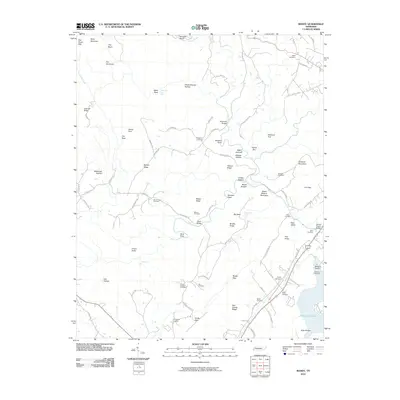
2010 Map of Roddy
USGS Topo · Published 2010About this map
Watts Bar Lake anchors the southeastern corner of this Tennessee landscape, where the waters of Camp Creek and Roddy Spring meet the reservoir. The terrain is defined by a series of parallel ridges including Wilson Ridge, Pine Ridge, and Dug Hill Ridge, creating a landscape of sheltered hollows and high points. Numerous family and community burial sites are scattered throughout these valleys, such as Mount Zion Cemetery and Clifton Cemetery, suggesting a deeply rooted local history.
Find a feature on this map
91 named features on this map. Tap any name to fly to it.
Don’t see what you’re looking for? This feature index may not catch every label — zoom into the map to look around manually.
Map Details
Editions of this 2010 Roddy Map
This is the sole edition of this map. No revisions or reprints were ever made.
Other maps of this area

1887 · Kingston
USGS Topo · 1:125,000

1891 · Kingston
USGS Topo · 1:125,000

1893 · Kingston
USGS Topo · 1:125,000

1935 · Rockwood
USGS Topo · 1:24,000

1935 · Pennine
USGS Topo · 1:24,000

1936 · Roddy
USGS Topo · 1:24,000
1936 · Ozone
USGS Topo · 1:24,000

1936 · Cardiff
USGS Topo · 1:24,000

1936 · Spring City
USGS Topo · 1:24,000
1936 · Grassy Cove
USGS Topo · 1:24,000