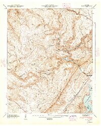
1947 Map of Roddy
USGS Topo · Published 1948About this map
The Cumberland Escarpment dominates this landscape, creating a dramatic physical divide between the plateau to the west and the valley floor to the east. Settlements like Grandview and Roddy are established along early transit corridors, with the Southern Railroad running parallel to the ridge through the valley. The map reveals a community deeply rooted in the land, evidenced by numerous family-named landmarks and rural institutions such as Mt Zion, the Big Sandy Sch, and the Boy Scout Memorial Bean Cem. Water plays a central role in the local geography, from the winding path of Whites Creek to the newly formed shoreline of the Watts Bar Reservoir. These features, along with localized landmarks like the Gibson Inn and Baker Bridge, document the mid-century infrastructure and social fabric of the Rhea, Roane, and Cumberland county borders.
Find a feature on this map
102 named features on this map. Tap any name to fly to it.
Don’t see what you’re looking for? This feature index may not catch every label — zoom into the map to look around manually.
Map Details
Editions of this 1947 Roddy Map
This is the sole edition of this map. No revisions or reprints were ever made.
Other maps of this area

1887 · Kingston
USGS Topo · 1:125,000

1891 · Kingston
USGS Topo · 1:125,000

1893 · Kingston
USGS Topo · 1:125,000

1935 · Rockwood
USGS Topo · 1:24,000

1935 · Pennine
USGS Topo · 1:24,000

1936 · Roddy
USGS Topo · 1:24,000
1936 · Ozone
USGS Topo · 1:24,000

1936 · Cardiff
USGS Topo · 1:24,000

1936 · Spring City
USGS Topo · 1:24,000
1936 · Grassy Cove
USGS Topo · 1:24,000