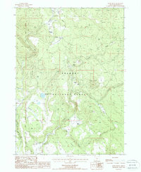
1988 Map of Rodeo Butte
USGS Topo · Published 1988About this map
The Fremont National Forest defines this high-elevation landscape in Klamath County, where historical ranching and timber interests have left a clear mark. The western edge of the quadrangle is bisected by the Old Indian Treaty Boundary, an important historical line that once partitioned these lands. Water management is a primary theme of the terrain, as seen in the numerous stock ponds and the O'Connors Puddle Reservoir situated within the Basin. Evidence of early industrial and transportation infrastructure appears in the Old RR Gr Glade and several Gravel Pits. Local ranching history is anchored by the Obenchain Ranch, Griffin Ranch, and McCartie Ranch, which sit among landmarks like Rodeo Butte and Rimrock Point. This environment is punctuated by several springs, including Cold Spring and Meryl Springs, supporting livestock in an area defined by deep drainages like Fivemile Creek and Preacher Creek.
Find a feature on this map
25 named features on this map. Tap any name to fly to it.
Don’t see what you’re looking for? This feature index may not catch every label — zoom into the map to look around manually.
Map Details
Editions of this 1988 Rodeo Butte Map
This is the sole edition of this map. No revisions or reprints were ever made.
Other maps of this area

1889 · Klamath
USGS Topo · 1:250,000

1894 · Klamath
USGS Topo · 1:250,000

1955 · Klamath Falls
USGS Topo · 1:250,000

1958 · Klamath Falls
USGS Topo · 1:250,000

1960 · Riverbed Butte
USGS Topo · 1:62,500

1960 · Bly
USGS Topo · 1:62,500

1960 · Fishhole Mtn
USGS Topo · 1:62,500

1966 · Shake Butte
USGS Topo · 1:24,000

1966 · Sandhill Crossing
USGS Topo · 1:24,000

1974 · Lake Abert
USGS Topo · 1:100,000