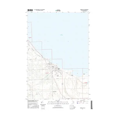
2017 Map of Rogers City
USGS Topo · Published 2017About this map
Rogers City anchors this Presque Isle County coastline, where the industrial and natural landscapes of northern Michigan meet the waters of Lake Huron. The map captures the significant footprint of the limestone industry at Calcite and Quarry Point, showing the massive excavation areas and shipping infrastructure that have long defined the local economy. Beyond the industrial zones, the terrain is marked by a network of waterways including Trout River, Nagels Cr, and Hartwick Cr which flow toward the lake.
Find a feature on this map
53 named features on this map. Tap any name to fly to it.
Don’t see what you’re looking for? This feature index may not catch every label — zoom into the map to look around manually.
Map Details
Editions of this 2017 Rogers City Map
This is the sole edition of this map. No revisions or reprints were ever made.
Other maps of this area

1954 · Alpena
USGS Topo · 1:250,000

1957 · Alpena
USGS Topo · 1:250,000

1958 · Alpena
USGS Topo · 1:250,000

1969 · Alpena
USGS Topo · 1:250,000

1971 · Rogers City
USGS Topo · 1:24,000

1971 · Hawks
USGS Topo · 1:24,000

1971 · Metz
USGS Topo · 1:24,000
1971 · Moltke
USGS Topo · 1:24,000
1971 · Adams Point
USGS Topo · 1:24,000
1971 · Posen
USGS Topo · 1:24,000