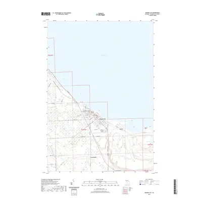
2019 Map of Rogers City
USGS Topo · Published 2019About this map
Rogers City serves as the focal point of this coastal survey, where the street grid meets the western shores of Lake Huron. The map captures a blend of civic infrastructure and maritime landscape, anchored by the Presque Isle County Courthouse and the nearby Rogers City Memorial Park Cem. To the southeast, the industrial footprint of Calcite and the geological feature of Quarry Point indicate the area's long-standing connection to coastal resource extraction. Moving inland, the landscape transitions from the developed corridors of the Presque Isle County Airport to the rural character of Bruningville. Waterways like Trout River and Hartwick Cr drain the low-lying terrain north of Little Lake, while the Huron Sunrise Trail follows the shoreline, tracing the path of former transportation routes along the lake.
Find a feature on this map
52 named features on this map. Tap any name to fly to it.
Don’t see what you’re looking for? This feature index may not catch every label — zoom into the map to look around manually.
Map Details
Editions of this 2019 Rogers City Map
This is the sole edition of this map. No revisions or reprints were ever made.
Other maps of this area

1954 · Alpena
USGS Topo · 1:250,000

1957 · Alpena
USGS Topo · 1:250,000

1958 · Alpena
USGS Topo · 1:250,000

1969 · Alpena
USGS Topo · 1:250,000

1971 · Rogers City
USGS Topo · 1:24,000

1971 · Hawks
USGS Topo · 1:24,000

1971 · Metz
USGS Topo · 1:24,000
1971 · Moltke
USGS Topo · 1:24,000
1971 · Adams Point
USGS Topo · 1:24,000
1971 · Posen
USGS Topo · 1:24,000