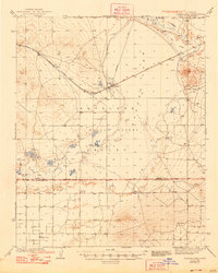
1942 Map of Rogers Lake
USGS Topo · Published 1948About this map
Muroc Bombing and Gunnery Range occupies a significant portion of this high desert landscape, highlighting the military transformation of the region during the early 1940s. The arid basin of the Mojave Desert is dominated by the expansive Rogers Lake and nearby Buckhorn Lake, which provided a natural, level surface for aviation activities. Along the Atchison Topeka and Santa Fe railroad, small rail-dependent settlements like Muroc, Fluhr, and Solon served as anchors for the sparse population.
Find a feature on this map
34 named features on this map. Tap any name to fly to it.
Don’t see what you’re looking for? This feature index may not catch every label — zoom into the map to look around manually.
Map Details
Editions of this 1942 Rogers Lake Map
2 editions found

Other maps of this area

1915 · Elizabeth Lake
USGS Topo · 1:125,000

1915 · Searles Lake
USGS Topo · 1:250,000

1915 · Mojave
USGS Topo · 1:125,000

1917 · Elizabeth Lake
USGS Topo · 1:125,000

1930 · Joshua
USGS Topo · 1:24,000

1930 · Roosevelt School
USGS Topo · 1:24,000

1930 · Casa Desierta
USGS Topo · 1:24,000

1931 · Hi Vista
USGS Topo · 1:24,000

1933 · Casa Desierta
USGS Topo · 1:24,000

1933 · Roosevelt School
USGS Topo · 1:24,000