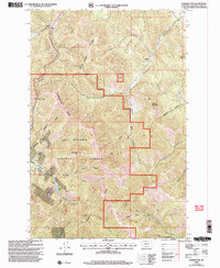
2001 Map of Rogers Pass
USGS Topo · Published 2004About this map
Helena National Forest dominates this section of the Northern Rockies, where the high-altitude landscape is bisected by the Continental Divide. This 2001 revision illustrates the region's complex relationship with industry and access, particularly at the Mike Horse Mine near the headwaters of the Blackfoot River. The presence of the Lincoln Ranger District and numerous forest tracks like the Denton 4WD Road suggests an area managed for both resource extraction and rugged transit. Historic mining activity is evident at the Communication Site Mine and Anaconda Hill, situated amongst steep peaks like Sunset Mountain and Roberts Mountain. Strategic points like Rogers Pass mark the crossing over the divide, while the eastern slopes drain into the Dearborn River system, punctuated by natural landmarks such as Blacktail Cave.
Find a feature on this map
42 named features on this map. Tap any name to fly to it.
Don’t see what you’re looking for? This feature index may not catch every label — zoom into the map to look around manually.
Map Details
Editions of this 2001 Rogers Pass Map
This is the sole edition of this map. No revisions or reprints were ever made.
Other maps of this area

1889 · Helena
USGS Topo · 1:250,000

1893 · Helena
USGS Topo · 1:250,000

1899 · Helena
USGS Topo · 1:250,000

1903 · Helena
USGS Topo · 1:250,000

1943 · Hogan
USGS Topo · 1:125,000

1947 · Butte
USGS Topo · 1:250,000

1955 · Choteau
USGS Topo · 1:250,000

1957 · Choteau
USGS Topo · 1:250,000

1958 · Butte
USGS Topo · 1:250,000

1958 · Choteau
USGS Topo · 1:250,000