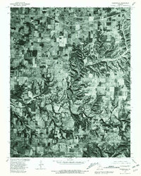
1979 Map of Rogersville
USGS Topo · Published 1981About this map
Rogersville and Sparta anchor this 1979 orthophotoquad, which captures the Missouri landscape through rectified aerial imagery. The transition from the rectilinear grid of agricultural fields in the north to the heavily timbered, dissecting drainages of the southern portion of the map illustrates the local topography. Finley Creek winds through the southeastern quadrant, its path defined by dense vegetation and steep relief that stands in sharp contrast to the cleared homesteads and farm plots near Cody. Produced by the Geological Survey in cooperation with the Soil Conservation Service, this document overlays traditional land lines from 1970 onto 1979 photoimagery, providing a rare look at land use and development patterns in this part of Greene and Christian Counties during the late 1970s.
Find a feature on this map
6 named features on this map. Tap any name to fly to it.
Don’t see what you’re looking for? This feature index may not catch every label — zoom into the map to look around manually.
Map Details
Editions of this 1979 Rogersville Map
This is the sole edition of this map. No revisions or reprints were ever made.
Other maps of this area

1884 · Springfield
USGS Topo · 1:125,000

1886 · Springfield
USGS Topo · 1:125,000

1907 · Forsyth
USGS Topo · 1:125,000

1937 · Galloway
USGS Topo · 1:24,000

1937 · Bradleyville
USGS Topo · 1:48,000

1937 · Ozark
USGS Topo · 1:48,000

1939 · Fordland
USGS Topo · 1:62,500

1942 · Fordland
USGS Topo · 1:62,500

1943 · Ozark
USGS Topo · 1:62,500

1943 · Bradleyville
USGS Topo · 1:62,500