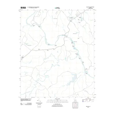
2011 Map of Roland
USGS Topo · Published 2011About this map
The Flint River carves a winding path through the center of this Georgia landscape, defining a terrain of islands and shoals between the communities of Roland and Pleasant Hill. This 2011 survey documents a rural environment shaped by the river's hydrology, featuring numerous named landforms such as Seven Islands, Yellow Jacket Shoals, and Gulf Mountain. The geography is notably rich in family and local history, as evidenced by a high density of small burial grounds including Grantland Cemetery, Pye Cemetery, and Smith Cemetery. The mapping of several dam sites, such as Franklins Pond Dam and Hammonds Lake Dam, alongside river crossings like Wynns Bridge, illustrates the local management of the watershed. Researchers can trace the network of secondary routes like Adams Ferry Rd and Spewell Bluff Rd that link these scattered settlements and cemeteries to the river's edge.
Find a feature on this map
64 named features on this map. Tap any name to fly to it.
Don’t see what you’re looking for? This feature index may not catch every label — zoom into the map to look around manually.
Map Details
Editions of this 2011 Roland Map
This is the sole edition of this map. No revisions or reprints were ever made.
Other maps of this area

1907 · Talbotton
USGS Topo · 1:125,000

1934 · Warm Springs
USGS Topo · 1:62,500

1935 · Thomaston
USGS Topo · 1:48,000

1936 · Warm Springs
USGS Topo · 1:62,500

1939 · Thomaston
USGS Topo · 1:62,500

1950 · Talbotton
USGS Topo · 1:24,000

1950 · Talbotton
USGS Topo · 1:62,500

1955 · Talbotton
USGS Topo · 1:24,000
1955 · Talbotton
USGS Topo · 1:62,500

1955 · Phenix City
USGS Topo · 1:250,000