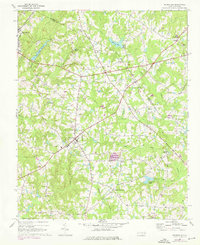
1967 Map of Rolesville
USGS Topo · Published 1975About this map
Rolesville and the eastern edge of Wake Forest anchor this mid-1960s landscape as it transitions through early 1970s updates. The terrain is defined by a network of small creeks and community hubs, including Fowlers Crossroads and Harris Crossroads. Evidence of older transportation routes is visible in the Old Railroad Grade running east of Lassiter, which contrasts with the active Seaboard Coast Line passing through Wake Forest.
Find a feature on this map
37 named features on this map. Tap any name to fly to it.
Don’t see what you’re looking for? This feature index may not catch every label — zoom into the map to look around manually.
Map Details
Editions of this 1967 Rolesville Map
3 editions found
Other maps of this area

1943 · Raleigh
USGS Topo · 1:62,500

1943 · Creedmoor
USGS Topo · 1:62,500

1944 · Creedmoor
USGS Topo · 1:62,500

1951 · Raleigh
USGS Topo · 1:62,500

1953 · Raleigh
USGS Topo · 1:250,000

1953 · Greensboro
USGS Topo · 1:250,000

1954 · Greensboro
USGS Topo · 1:250,000

1954 · Raleigh
USGS Topo · 1:250,000

1962 · Greensboro
USGS Topo · 1:250,000

1966 · Greensboro
USGS Topo · 1:250,000