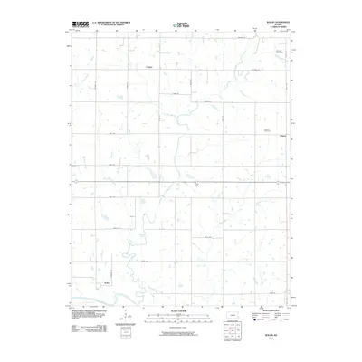
2009 Map of Rollin
USGS Topo · Published 2009About this map
Big Creek winds centrally through this Neosho County landscape, joined by numerous tributaries like Turkey Branch, Pecan Creek, and Draw Creek. The area is defined by a grid of rural roads and the small community clusters of Leanna, Odense, and Rollin. The settlement at Rollin is situated in the southwest near a bend of the Neosho River, while the northern section features the Nyman Lake Dam on Rocky Branch.
Find a feature on this map
30 named features on this map. Tap any name to fly to it.
Don’t see what you’re looking for? This feature index may not catch every label — zoom into the map to look around manually.
Map Details
Editions of this 2009 Rollin Map
This is the sole edition of this map. No revisions or reprints were ever made.
Other maps of this area

1886 · Iola
USGS Topo · 1:125,000

1893 · Iola
USGS Topo · 1:125,000

1904 · Iola
USGS Topo · 1:125,000

1947 · Joplin
USGS Topo · 1:250,000

1948 · Erie
USGS Topo · 1:62,500

1949 · Erie
USGS Topo · 1:62,500

1949 · Joplin
USGS Topo · 1:250,000
1951 · Chanute
USGS Topo · 1:62,500

1954 · Joplin
USGS Topo · 1:250,000

1958 · Joplin
USGS Topo · 1:250,000