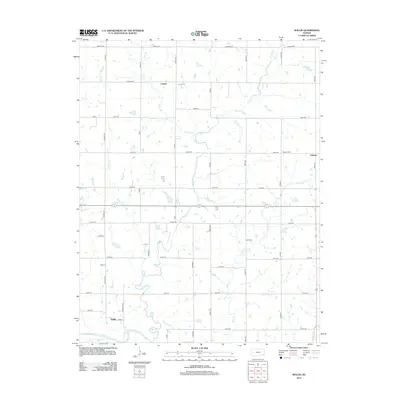
2012 Map of Rollin
USGS Topo · Published 2012About this map
Leanna, Odense, and Rollin anchor this rural landscape in southeastern Kansas, where a dense grid of section roads like Arizona Rd and Meade Rd defines the agricultural layout. The terrain is intricately carved by several waterways, most notably the Neosho River in the southwest corner and the expansive drainage of Big Creek, which snakes through the center of the quadrangle. Local history is preserved at the Leanna Cem and Odense Cem, providing essential points of reference for genealogists. The map also captures the varied aquatic landscape of the region, from the smaller Numan Lake to numerous named tributaries including Turkey Br, Sutton Cr, and Pecan Cr. This 2012 survey illustrates how modern infrastructure and 19th-century settlement patterns continue to coexist in Neosho County.
Find a feature on this map
48 named features on this map. Tap any name to fly to it.
Don’t see what you’re looking for? This feature index may not catch every label — zoom into the map to look around manually.
Map Details
Editions of this 2012 Rollin Map
This is the sole edition of this map. No revisions or reprints were ever made.
Other maps of this area

1886 · Iola
USGS Topo · 1:125,000

1893 · Iola
USGS Topo · 1:125,000

1904 · Iola
USGS Topo · 1:125,000

1947 · Joplin
USGS Topo · 1:250,000

1948 · Erie
USGS Topo · 1:62,500

1949 · Erie
USGS Topo · 1:62,500

1949 · Joplin
USGS Topo · 1:250,000
1951 · Chanute
USGS Topo · 1:62,500

1954 · Joplin
USGS Topo · 1:250,000

1958 · Joplin
USGS Topo · 1:250,000