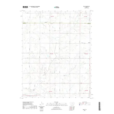
2018 Map of Rollin
USGS Topo · Published 2018About this map
The Neosho River snakes across the southwestern corner of this Neosho County landscape, defining the local drainage system alongside Big Creek. The area is characterized by a grid of rural section roads like Arizona Rd and Alabama Rd that connect small agrarian communities. Leanna serves as a northern focal point near the Allen County line, while Odense sits further east, both accompanied by their respective burial grounds, Leanna Cem and Odense Cem. Smaller watercourses such as Turkey Br, Goose Cr, and Pecan Cr carve gentle valleys through the prairie, feeding into the larger river system. To the northeast, Nyman Lake and Rocky Br punctuate the terrain, showing the varied water features of the eastern Kansas plains. This survey captures the enduring rural structure of the region, where family-named landmarks and small-scale water bodies remain central to the geography.
Find a feature on this map
38 named features on this map. Tap any name to fly to it.
Don’t see what you’re looking for? This feature index may not catch every label — zoom into the map to look around manually.
Map Details
Editions of this 2018 Rollin Map
This is the sole edition of this map. No revisions or reprints were ever made.
Other maps of this area

1886 · Iola
USGS Topo · 1:125,000

1893 · Iola
USGS Topo · 1:125,000

1904 · Iola
USGS Topo · 1:125,000

1947 · Joplin
USGS Topo · 1:250,000

1948 · Erie
USGS Topo · 1:62,500

1949 · Erie
USGS Topo · 1:62,500

1949 · Joplin
USGS Topo · 1:250,000
1951 · Chanute
USGS Topo · 1:62,500

1954 · Joplin
USGS Topo · 1:250,000

1958 · Joplin
USGS Topo · 1:250,000