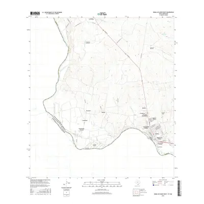
2016 Map of Roma-Los Saenz West
USGS Topo · Published 2016About this map
The Rio Grande serves as the international boundary on this 2016 survey, defining the southern limit of Starr Co as it meanders past Fronton Island. The landscape is characterized by numerous seasonal watercourses, including Arroyo del Tigre and Arroyo de los Mudos, which carve through the terrain toward the river. Historically significant settlements and colonias are concentrated along the river corridor, where the historic core of Roma and Roma-Los Saenz meet the modern connectivity of the Roma-San Pedro International Bridge. The map details a transition from dense urban street grids, such as those near E Grant St, to the more dispersed residential patterns of Fronton Ranchettes and Campobello Colonia. Notable family-named landmarks like Guadalupe Guerra and De La Cruz Colonia illustrate the regional land-use patterns common to this section of the Texas-Mexico borderlands.
Find a feature on this map
59 named features on this map. Tap any name to fly to it.
Don’t see what you’re looking for? This feature index may not catch every label — zoom into the map to look around manually.
Map Details
Editions of this 2016 Roma-Los Saenz West Map
This is the sole edition of this map. No revisions or reprints were ever made.
Other maps of this area

1938 · Falcon
USGS Topo · 1:62,500

1938 · El Sauz
USGS Topo · 1:62,500

1949 · Mc Allen
USGS Topo · 1:250,000

1954 · McAllen
USGS Topo · 1:250,000

1956 · Escobares
USGS Topo · 1:62,500

1956 · Roma
USGS Topo · 1:62,500

1957 · Mc Allen
USGS Topo · 1:250,000

1962 · McAllen
USGS Topo · 1:250,000

1965 · Los Garzas
USGS Topo · 1:24,000

1965 · Salineno
USGS Topo · 1:24,000