
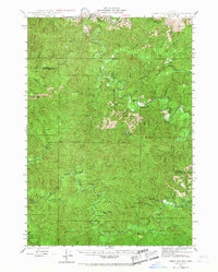
1942 Map of Roman Nose Mtn
USGS Topo · Published 1962About this map
Roman Nose Mtn stands as a prominent landmark in this 1942 survey of the Coast Range, where the complex drainage basins of the Siuslaw River and Smith River converge. The landscape is defined by its industrial and residential isolation, characterized by small homesteads and essential rural infrastructure. Named properties such as Luce Place, Hess Ranch, and Damewoods Place are scattered among the dense network of creeks, providing valuable location data for genealogists tracking early twentieth-century settlers in this timber-rich region.
Find a feature on this map
55 named features on this map. Tap any name to fly to it.
Don’t see what you’re looking for? This feature index may not catch every label — zoom into the map to look around manually.
Map Details
Editions of this 1942 Roman Nose Mtn Map
2 editions found
Other maps of this area

1909 · Elmira
USGS Topo · 1:62,500

1918 · Mapleton
USGS Topo · 1:48,000

1919 · Earl
USGS Topo · 1:48,000

1922 · Elmira
USGS Topo · 1:62,500

1940 · Mapleton
USGS Topo · 1:62,500

1941 · Blachly
USGS Topo · 1:62,500

1942 · Elmira
USGS Topo · 1:62,500

1942 · Blachly
USGS Topo · 1:62,500

1942 · Crow
USGS Topo · 1:62,500

1943 · Goodwin Peak
USGS Topo · 1:62,500