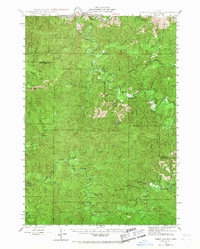
1942 Map of Roman Nose Mtn
USGS Topo · Published 1967About this map
Roman Nose Mountain towers over this section of the Oregon Coast Range, marking the rugged divide between the Siuslaw River and Smith River drainage basins. Surveyed in the early 1940s, the map reveals a landscape defined by isolated homesteads and forest service infrastructure. Settled pockets like Linslaw and Gunter are connected by a thin network of unimproved roads and trails, while specific family-named landmarks such as the Luce Place, Hess Ranch, and Damewoods Place point to the era's rural habitation patterns.
Find a feature on this map
47 named features on this map. Tap any name to fly to it.
Don’t see what you’re looking for? This feature index may not catch every label — zoom into the map to look around manually.
Map Details
Editions of this 1942 Roman Nose Mtn Map
2 editions found
Other maps of this area

1909 · Elmira
USGS Topo · 1:62,500

1918 · Mapleton
USGS Topo · 1:48,000

1919 · Earl
USGS Topo · 1:48,000

1922 · Elmira
USGS Topo · 1:62,500

1940 · Mapleton
USGS Topo · 1:62,500

1941 · Blachly
USGS Topo · 1:62,500

1942 · Elmira
USGS Topo · 1:62,500

1942 · Blachly
USGS Topo · 1:62,500

1942 · Crow
USGS Topo · 1:62,500

1942 · Roman Nose Mtn
USGS Topo · 1:62,500