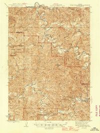
1945 Map of Roman Nose Mtn
USGS Topo · Published 1945About this map
The Siuslaw River and Smith River systems dominate this mid-century topographic survey of the coastal mountains, tracing the complex drainages of North Sister Creek and South Sister Creek. During the 1940s, this landscape was a working timber and ranching environment within the Siuslaw National Forest. The map documents a network of isolated homesteads and specific locales like Hess Ranch, Damewoods Place, and Argue, which reflect the area's early settlement patterns. Higher elevations are marked by critical infrastructure of the era, such as the Roman Nose Mtn Lookout and the Twin Sisters Guard Sta. Transportation is defined by the winding course of the Southern Pacific railroad in the north and various mountain trails. Education for these remote communities centered on small facilities like Alma Sch and Panther Creek Sch, providing a clear record of local social geography before major modern development.
Find a feature on this map
53 named features on this map. Tap any name to fly to it.
Don’t see what you’re looking for? This feature index may not catch every label — zoom into the map to look around manually.
Map Details
Editions of this 1945 Roman Nose Mtn Map
2 editions found

Other maps of this area

1909 · Elmira
USGS Topo · 1:62,500

1918 · Mapleton
USGS Topo · 1:48,000

1919 · Earl
USGS Topo · 1:48,000

1922 · Elmira
USGS Topo · 1:62,500

1940 · Mapleton
USGS Topo · 1:62,500

1941 · Blachly
USGS Topo · 1:62,500

1942 · Elmira
USGS Topo · 1:62,500

1942 · Blachly
USGS Topo · 1:62,500

1942 · Crow
USGS Topo · 1:62,500

1942 · Roman Nose Mtn
USGS Topo · 1:62,500