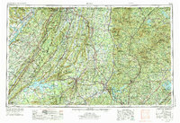
1958 Map of Rome
USGS Topo · Published 1974About this map
Lookout Mountain and Sand Mountain dominate the western landscape of this mid-century survey, defining the ridgeline-and-valley geography that shaped North Georgia's development. At the center, Rome sits at the confluence of the Oostanaula River and Etowah River, serving as a critical regional hub for transportation and education, anchored by Berry College and Shorter College. The map captures the significant industrial and recreational impact of postwar hydroelectric projects, with Weiss Lake and Allatoona Lake showing established shorelines.
Find a feature on this map
188 named features on this map. Tap any name to fly to it.
Don’t see what you’re looking for? This feature index may not catch every label — zoom into the map to look around manually.
Map Details
Editions of this 1958 Rome Map
3 editions found

Other maps of this area

1885 · Gadsden
USGS Topo · 1:125,000

1886 · Dalton
USGS Topo · 1:125,000

1886 · Cleveland
USGS Topo · 1:125,000

1886 · Ringgold
USGS Topo · 1:125,000

1886 · Rome
USGS Topo · 1:125,000

1886 · Stevenson
USGS Topo · 1:125,000

1886 · Dahlonega
USGS Topo · 1:125,000

1888 · Gadsden
USGS Topo · 1:125,000

1888 · Ellijay
USGS Topo · 1:125,000

1888 · Chattanooga
USGS Topo · 1:125,000