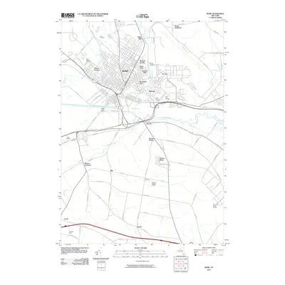
2010 Map of Rome
USGS Topo · Published 2010About this map
Rome sits at a historic geographic crossroads, where the Mohawk River and Wood Creek flow through the flatlands of Oneida County. This modern survey illustrates how contemporary residential developments like Mohawk Gardens and Lynch Tract have expanded the city's footprint alongside older named areas such as Ridge Mills and Riverdale. The landscape is dotted with numerous memorial sites, including Rome Cemetery and the Oneida County Cemetery, providing clear geographic markers for genealogical research and family history. Moving south and east from the urban center, the terrain shifts into a mix of aviation hubs and smaller hamlets. Both the Stanwix Heights Airport and the Oneida County Airport are prominent landmarks, while localized settlements like Wright Settlement and Spencer Settlement preserve the names of early resident families within the 21st-century road network.
Find a feature on this map
75 named features on this map. Tap any name to fly to it.
Don’t see what you’re looking for? This feature index may not catch every label — zoom into the map to look around manually.
Map Details
Editions of this 2010 Rome Map
This is the sole edition of this map. No revisions or reprints were ever made.
Other maps of this area

1895 · Oriskany
USGS Topo · 1:62,500

1895 · Oneida
USGS Topo · 1:62,500

1898 · Oneida
USGS Topo · 1:62,500

1898 · Oriskany
USGS Topo · 1:62,500

1902 · Oneida
USGS Topo · 1:62,500

1904 · Boonville
USGS Topo · 1:62,500

1905 · Taberg
USGS Topo · 1:62,500

1939 · Oneida
USGS Topo · 1:62,500

1943 · Lee Center
USGS Topo · 1:31,680
1946 · Oneida
USGS Topo · 1:62,500