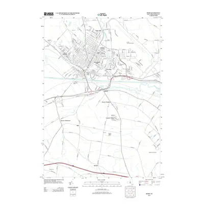
2013 Map of Rome
USGS Topo · Published 2013About this map
The Mohawk River and the dual corridors of the Erie Canal and Black River Canal converge at the center of this map, defining the historic transit-oriented geography of the region. This 2013 survey documents a complex network of residential developments and industrial aviation infrastructure, notably Griffiss International Airport and its surrounding support areas like Air City. The urban center is surrounded by smaller, distinct neighborhoods such as Ridge Mills and Lynch Tract, while outlying areas retain their agricultural identity at Happy Valley Farms and Spencer Settlement. Local history is deeply embedded in the landscape through numerous cemeteries, including Rome Cem and Saint Marys Cem, and distinctive landmarks like the Railroad Street Bridge and the West Rome Drive-In.
Find a feature on this map
202 named features on this map. Tap any name to fly to it.
Don’t see what you’re looking for? This feature index may not catch every label — zoom into the map to look around manually.
Map Details
Editions of this 2013 Rome Map
This is the sole edition of this map. No revisions or reprints were ever made.
Other maps of this area

1895 · Oriskany
USGS Topo · 1:62,500

1895 · Oneida
USGS Topo · 1:62,500

1898 · Oneida
USGS Topo · 1:62,500

1898 · Oriskany
USGS Topo · 1:62,500

1902 · Oneida
USGS Topo · 1:62,500

1904 · Boonville
USGS Topo · 1:62,500

1905 · Taberg
USGS Topo · 1:62,500

1939 · Oneida
USGS Topo · 1:62,500

1943 · Lee Center
USGS Topo · 1:31,680
1946 · Oneida
USGS Topo · 1:62,500