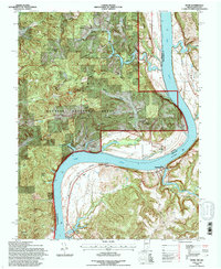
1993 Map of Rome
USGS Topo · Published 1996About this map
The Ohio River forms a sweeping oxbow as it defines the border between Indiana and Kentucky, anchoring this detailed 1993 revision of the Rome area. Along the northern bank, the settlement of Rome sits near a prominent bend, while across the water in Kentucky, the towns of Stephensport, Addison, and Holt follow the river’s path. The landscape is deeply dissected by drainages like Sinking Creek and Bear Creek, creating a series of named ridges and points such as Bill Point and Solomon Bryant Hill.
Find a feature on this map
36 named features on this map. Tap any name to fly to it.
Don’t see what you’re looking for? This feature index may not catch every label — zoom into the map to look around manually.
Map Details
Editions of this 1993 Rome Map
This is the sole edition of this map. No revisions or reprints were ever made.
Other maps of this area

1928 · Hardinsburg
USGS Topo · 1:48,000

1931 · Hardinsburg
USGS Topo · 1:62,500

1934 · Cannelton
USGS Topo · 1:62,500

1947 · Lodiburg
USGS Topo · 1:24,000

1947 · Hardinsburg
USGS Topo · 1:24,000

1947 · Hardinsburg
USGS Topo · 1:62,500

1949 · Cannelton
USGS Topo · 1:24,000

1950 · Alton
USGS Topo · 1:62,500

1950 · Alton
USGS Topo · 1:24,000

1951 · Alton
USGS Topo · 1:24,000