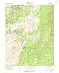
1971 Map of Ronceverte
USGS Topo · Published 1975About this map
The Greenbrier River anchors this early 1970s landscape, winding past the city of Ronceverte where the Chesapeake and Ohio railroad corridor follows the northern bank. This survey documents the rural character of southeastern West Virginia, highlighting the community of Organ Cave and the spread of historical landmarks across Irish Corner. The terrain is defined by the sharp descent of White Rock Mountain and Jones Mountain, which drop into the drainage basins of Second Creek and Hokes Creek. Numerous rural meeting houses and burial sites, such as Salem Ch, Elizabeth Chapel, and Morgan Cem, are scattered along the ridge roads. Small rural hubs like Secondcreek and Monitor appear near the intersection of mountain drafts and local watercourses, illustrating the traditional settlement patterns of Greenbrier and Monroe counties before significant modern expansion.
Find a feature on this map
41 named features on this map. Tap any name to fly to it.
Don’t see what you’re looking for? This feature index may not catch every label — zoom into the map to look around manually.
Map Details
Editions of this 1971 Ronceverte Map
This is the sole edition of this map. No revisions or reprints were ever made.
Other maps of this area

1887 · Hinton
USGS Topo · 1:125,000

1887 · Lewisburg
USGS Topo · 1:125,000

1891 · Lewisburg
USGS Topo · 1:125,000

1892 · Hinton
USGS Topo · 1:125,000

1921 · Alderson
USGS Topo · 1:48,000

1921 · White Sulphur Springs
USGS Topo · 1:48,000

1921 · Clintonville
USGS Topo · 1:48,000

1921 · Ronceverte
USGS Topo · 1:48,000

1923 · Clintonville
USGS Topo · 1:62,500

1923 · White Sulphur Springs
USGS Topo · 1:62,500