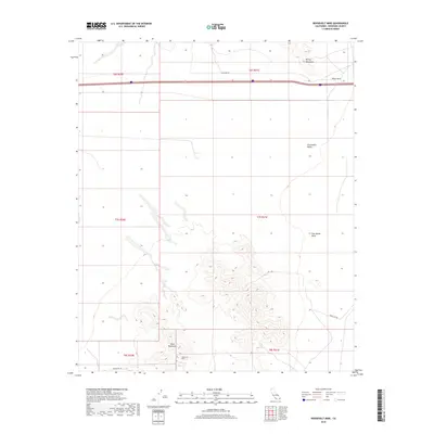
2018 Map of Roosevelt Mine
USGS Topo · Published 2018About this map
The Roosevelt Mine stands as a focal point in this 2018 survey of the Colorado Desert, positioned at the southern edge of the Mule Mountains. The landscape is defined by vast alluvial basins and arid uplands, with the Chuckwalla Valley extending across the central portion and the Palo Verde Mesa rising to the east. Transportation and infrastructure follow the contours of the terrain and historical routes, including the Bradshaw Trl, a path with deep roots in regional mining and stagecoach history. To the north, the McCoy Mountains and the distinctive Black Rock landmark overlook a corridor of utility development along Gas Line Rd. This map captures a transition point between natural desert formations and the industrial markers of extraction and passage, such as the Gravel Pit Rd, reflecting the modern character of this Riverside County landscape.
Find a feature on this map
15 named features on this map. Tap any name to fly to it.
Don’t see what you’re looking for? This feature index may not catch every label — zoom into the map to look around manually.
Map Details
Editions of this 2018 Roosevelt Mine Map
This is the sole edition of this map. No revisions or reprints were ever made.
Other maps of this area

1942 · Blythe
USGS Topo · 1:250,000

1945 · Cibola
USGS Topo · 1:62,500

1951 · McCoy Wash
USGS Topo · 1:24,000

1951 · Cibola
USGS Topo · 1:62,500

1952 · Mc Coy Spring
USGS Topo · 1:62,500

1952 · Palo Verde
USGS Topo · 1:24,000

1952 · Ripley
USGS Topo · 1:24,000

1953 · Palo Verde Mountains
USGS Topo · 1:62,500

1954 · Salton Sea
USGS Topo · 1:250,000

1955 · Salton Sea
USGS Topo · 1:250,000