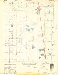
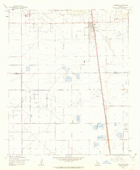
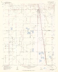
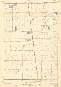
1947 Map of Rosamond
USGS Topo · Published 1947About this map
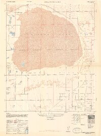
Rosamond serves as the primary hub of this high desert landscape, situated along the Southern Pacific railroad line in the western Mojave Desert. The post-war era layout shows a region defined by large land holdings and specialized aviation and recreational sites, including the Liberty Flying School and the Wagas Land Company. The map reveals a grid of planned thoroughfares like Avenue A and Neenach Road Avenue D that cut across the arid terrain, connecting scattered outposts such as the A Andrews Ranch. Social and sporting life of the late 1940s is represented by several private establishments, most notably the Glendale Rod and Gun Club, Hoffman Club, and Clarke Club, which suggest the area's role as a destination for outdoor enthusiasts and early desert aviation during California's mid-century expansion.
Find a feature on this map
18 named features on this map. Tap any name to fly to it.
Don’t see what you’re looking for? This feature index may not catch every label — zoom into the map to look around manually.
Map Details
Editions of this 1947 Rosamond Map
3 editions found
Other maps of this area

1915 · Elizabeth Lake
USGS Topo · 1:125,000

1917 · Elizabeth Lake
USGS Topo · 1:125,000

1930 · Oban
USGS Topo · 1:24,000
1931 · Esperanza School
USGS Topo · 1:24,000
1933 · Oban
USGS Topo · 1:24,000
1934 · Esperanza School
USGS Topo · 1:24,000
1943 · Rosamond
USGS Topo · 1:62,500
1943 · Willow Springs
USGS Topo · 1:62,500
1947 · Rosamond Lake
USGS Topo · 1:24,000
1947 · Bissell
USGS Topo · 1:24,000