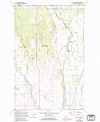
1962 Map of Rose Crossing
USGS Topo · Published 1995About this map
The Whitefish River and Stillwater River dominate this portion of Flathead County, carving distinct paths through the valley floor. To the west, the heavy timber of the Stillwater State Forest contrasts with the developed eastern plains where agricultural and civic life thrived in the early 1960s. This survey reveals a community anchored by several rural educational centers, including Pine Grove Sch and Halfmoon Sch, alongside the Midway Grange hall. The landscape is further defined by its infrastructure, from the Glacier Park International Airport to the concentrated settlement at Rose Crossing. The mapping highlights the transition from natural riparian corridors to managed resource areas, evidenced by numerous Gravel Pits and the Trinity Cem located near the southern boundary.
Find a feature on this map
20 named features on this map. Tap any name to fly to it.
Don’t see what you’re looking for? This feature index may not catch every label — zoom into the map to look around manually.
Map Details
Editions of this 1962 Rose Crossing Map
3 editions found
Other maps of this area

1943 · Kalispell
USGS Topo · 1:125,000

1957 · Kalispell
USGS Topo · 1:250,000

1960 · Kalispell
USGS Topo · 1:250,000

1961 · Kalispell
USGS Topo · 1:250,000

1962 · Columbia Falls South
USGS Topo · 1:24,000

1962 · Rose Crossing
USGS Topo · 1:24,000

1962 · Blue Grass Ridge
USGS Topo · 1:24,000

1962 · Beaver Lake
USGS Topo · 1:24,000

1962 · Creston
USGS Topo · 1:24,000

1962 · Rhodes
USGS Topo · 1:24,000