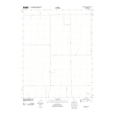
2010 Map of Rose Ranch
USGS Topo · Published 2010About this map
Rose Ranch serves as the namesake landmark for this portion of Kiowa County, which is defined by a strictly surveyed grid of rural passage. The landscape is marked by a network of long-distance county roads, including County Rd 31 and County Rd 30, which intersect across the high plains. A notable water feature in the southeastern corner, Government Spring, provides a vital point of interest in this otherwise dry agricultural or grazing environment. The arrangement of roads like County Hwy WW and County Road E suggests a region organized for large-scale ranching operations, where solitary homesteads and named springs represent the primary points of human habitation and resource management in the early twenty-first century.
Find a feature on this map
14 named features on this map. Tap any name to fly to it.
Don’t see what you’re looking for? This feature index may not catch every label — zoom into the map to look around manually.
Map Details
Editions of this 2010 Rose Ranch Map
This is the sole edition of this map. No revisions or reprints were ever made.
Other maps of this area

1891 · Las Animas
USGS Topo · 1:125,000

1892 · Lamar
USGS Topo · 1:125,000

1893 · Las Animas
USGS Topo · 1:125,000

1954 · Lamar
USGS Topo · 1:250,000

1955 · McClave
USGS Topo · 1:24,000

1955 · Tree Top Ranch
USGS Topo · 1:24,000

1955 · Lubers
USGS Topo · 1:24,000

1958 · Lamar
USGS Topo · 1:250,000

1968 · Rose Ranch
USGS Topo · 1:24,000
1968 · Swede Lake
USGS Topo · 1:24,000