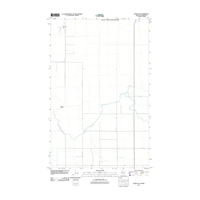
2010 Map of Roseau NE
USGS Topo · Published 2010About this map
The Canada - United States Boundary defines the northern edge of this Roseau County landscape, where the international line cuts across a low-lying, agricultural terrain. Much of the area is dominated by the Roseau Lakebed, a vast, flat expanse that historically drained into the meandering Roseau River. The river winds through the southern and eastern portions of the map, carving a serpentine path through the former lake floor. Rising slightly above the surrounding levels is Minnesota Hill in the northwestern corner, one of the few prominent topographic variations in this part of the Red River Valley region. A grid of rural roads, including County Hwy-118 and County Hwy-123, provides access to the scattered farmsteads and agricultural plots that utilize the rich soils of the former lake basin during the early twenty-first century.
Find a feature on this map
12 named features on this map. Tap any name to fly to it.
Don’t see what you’re looking for? This feature index may not catch every label — zoom into the map to look around manually.
Map Details
Editions of this 2010 Roseau NE Map
This is the sole edition of this map. No revisions or reprints were ever made.
Other maps of this area

1918 · Goos
USGS Topo · 1:62,500

1918 · Roseau
USGS Topo · 1:62,500

1943 · Goos
USGS Topo · 1:62,500

1954 · Roseau
USGS Topo · 1:250,000

1957 · Roseau
USGS Topo · 1:250,000

1958 · Roseau
USGS Topo · 1:250,000

1963 · Kenora
USGS Topo · 1:250,000
1966 · Pinecreek
USGS Topo · 1:24,000
1966 · Fox
USGS Topo · 1:24,000

1966 · Salol NW
USGS Topo · 1:24,000