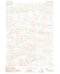
1987 Map of Rosebud Valley
USGS Topo · Published 1987About this map
The North Loup River winds through the southern reaches of this Sandhills landscape, carving the wide Rosebud Valley across Cherry County. This 1980s provisional survey illustrates a remote ranching environment defined by isolated outposts and a complex network of seasonal watercourses. Large landholdings are marked by family-named landmarks such as Knight Ranch near Betsy Creek and Warden Ranch on the edge of the German Flats. The terrain is characterized by stabilized dunes and depressions, where features like Palmer Lake and the marshy stretches of Mud Creek provide critical water sources for the cattle operations that have long sustained this region. A few 4WD tracks represent the primary infrastructure, connecting the Roseberry Ranch to the surrounding hills and emphasizing the vast distances between neighbors in this part of Nebraska.
Find a feature on this map
17 named features on this map. Tap any name to fly to it.
Don’t see what you’re looking for? This feature index may not catch every label — zoom into the map to look around manually.
Map Details
Editions of this 1987 Rosebud Valley Map
This is the sole edition of this map. No revisions or reprints were ever made.
Other maps of this area

1949 · Big Falls
USGS Topo · 1:62,500

1950 · Powderhorn Valley
USGS Topo · 1:62,500

1950 · Doughboy
USGS Topo · 1:62,500

1950 · Wolf Lake
USGS Topo · 1:62,500

1951 · Big Falls
USGS Topo · 1:62,500

1951 · Wolf Lake
USGS Topo · 1:62,500

1952 · Doughboy
USGS Topo · 1:62,500

1957 · Valentine
USGS Topo · 1:250,000

1959 · Valentine
USGS Topo · 1:250,000

1985 · Powderhorn Valley SW
USGS Topo · 1:24,000