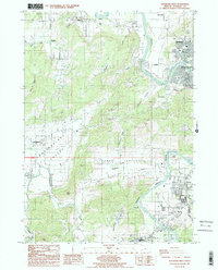
1987 Map of Roseburg West
USGS Topo · Published 1987About this map
The South Umpqua River winds through this 1980s landscape, serving as a primary corridor for the city of Roseburg and the southern settlement of Winston. The terrain transitions from the developed river valley to the broad agricultural expanses of Lookingglass Valley and Happy Valley. Small rural communities and named crossroads such as Melrose, Edenbower, and Lookingglass anchor the surrounding hillsides, while landmarks like Indian Nose and Swan Hill define the local topography. Evidence of the region's infrastructure is visible in the network of pipelines and powerlines, the Gaging Station on Lookingglass Creek, and Felts Field near the river. This survey captures the suburban and industrial expansion of the era, noting municipal features like the Sewage Disposal Plant and a Solid Waste Disposal Site alongside local landmarks like the Cem and various quarries.
Find a feature on this map
46 named features on this map. Tap any name to fly to it.
Don’t see what you’re looking for? This feature index may not catch every label — zoom into the map to look around manually.
Map Details
Editions of this 1987 Roseburg West Map
This is the sole edition of this map. No revisions or reprints were ever made.
Other maps of this area

1897 · Roseburg
USGS Topo · 1:125,000

1900 · Roseburg
USGS Topo · 1:125,000

1928 · Sitkum
USGS Topo · 1:125,000

1954 · Sutherlin
USGS Topo · 1:62,500

1955 · Camas Valley
USGS Topo · 1:62,500

1955 · Tyee
USGS Topo · 1:62,500

1955 · Roseburg
USGS Topo · 1:62,500

1958 · Roseburg
USGS Topo · 1:250,000

1959 · Roseburg
USGS Topo · 1:250,000

1979 · Roseburg
USGS Topo · 1:100,000