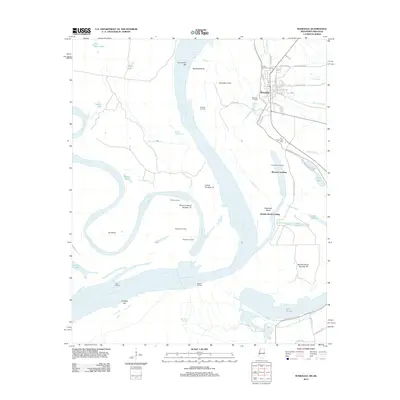
2012 Map of Rosedale
USGS Topo · Published 2012About this map
The Mississippi River and Arkansas River converge in a complex web of oxbow lakes, bars, and chutes near the river town of Rosedale. The intricate riparian geography of Bolivar County is defined by major hydrological features like Lake Beulah and Island Number 73, alongside numerous historical river access points including Klondike Landing, Napoleon Landing, and Prentiss Landing. The engineering of the floodplain is evident in the Mississippi River Levee and the Riverton Revetment, which protect the local infrastructure from the shifting river currents.
Find a feature on this map
60 named features on this map. Tap any name to fly to it.
Don’t see what you’re looking for? This feature index may not catch every label — zoom into the map to look around manually.
Map Details
Editions of this 2012 Rosedale Map
This is the sole edition of this map. No revisions or reprints were ever made.
Other maps of this area

1933 · Lamont
USGS Topo · 1:62,500

1939 · Pace
USGS Topo · 1:62,500

1939 · Big Island
USGS Topo · 1:62,500

1939 · Lamont
USGS Topo · 1:62,500

1939 · Choctaw
USGS Topo · 1:62,500

1953 · Greenwood
USGS Topo · 1:250,000

1956 · Greenwood
USGS Topo · 1:250,000

1967 · Lobdell
USGS Topo · 1:24,000
1969 · Choctaw
USGS Topo · 1:62,500
1969 · Beulah
USGS Topo · 1:24,000