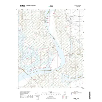
2018 Map of Rosedale
USGS Topo · Published 2018About this map
Mississippi River and Arkansas River hydrology dominates this riverine landscape at the border of Mississippi and Arkansas. The settlement of Rosedale serves as a focal point near the top of the sheet, situated along the eastern bank near Rosedale Bend and Knowlton Point. This area reflects the complex, shifting nature of the river system, documented through numerous abandoned channels and water bodies like Lake Beulah, Whiskey Chute, and the Napoleon Cutoff. Genealogists and local historians can find significant landmarks such as Pleasant Grove Cem and Anns Tabernacle Cem, providing evidence of the community's social fabric. The presence of Beulah Crevasse indicates the historical impact of the river's power on the regional geography, while named features like Beulah Island Number 74 and Island Number 73 trace the evolution of the main channel and state boundaries.
Find a feature on this map
73 named features on this map. Tap any name to fly to it.
Don’t see what you’re looking for? This feature index may not catch every label — zoom into the map to look around manually.
Map Details
Editions of this 2018 Rosedale Map
This is the sole edition of this map. No revisions or reprints were ever made.
Other maps of this area

1933 · Lamont
USGS Topo · 1:62,500

1939 · Pace
USGS Topo · 1:62,500

1939 · Big Island
USGS Topo · 1:62,500

1939 · Lamont
USGS Topo · 1:62,500

1939 · Choctaw
USGS Topo · 1:62,500

1953 · Greenwood
USGS Topo · 1:250,000

1956 · Greenwood
USGS Topo · 1:250,000

1967 · Lobdell
USGS Topo · 1:24,000
1969 · Choctaw
USGS Topo · 1:62,500
1969 · Beulah
USGS Topo · 1:24,000