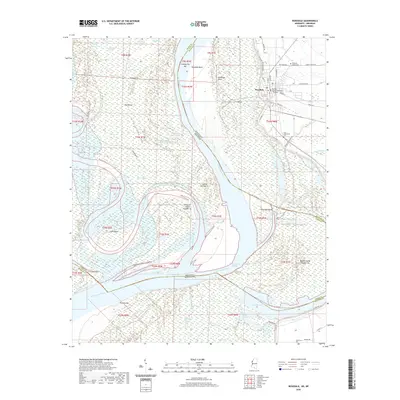
2020 Map of Rosedale
USGS Topo · Published 2020About this map
The Bolivar County Courthouse serves as a prominent landmark in this riverfront community, where the town of Rosedale sits at the meeting point of the Mississippi River and the Arkansas River. The landscape is defined by the complex hydrology of the Delta, featuring a network of secondary waterways like Lane Bayou, McNeil Slough, and Knowlton Bayou. This survey reveals the shifting nature of the riverbanks through named features like Cumbysville Bar, Prentiss Bar, and the massive Big Island. Genealogists will find several local burial sites, including Pleasant Grove Cem, Anns Tabernacle Cem, and Clark Cem, documenting the area's rural social history. Beyond the town grid, the terrain is fragmented by remnant oxbows and chutes, such as Lake Beulah and Whiskey Chute, which illustrate the enduring influence of the Napoleon Cutoff on the region's geography.
Find a feature on this map
72 named features on this map. Tap any name to fly to it.
Don’t see what you’re looking for? This feature index may not catch every label — zoom into the map to look around manually.
Map Details
Editions of this 2020 Rosedale Map
This is the sole edition of this map. No revisions or reprints were ever made.
Other maps of this area

1933 · Lamont
USGS Topo · 1:62,500

1939 · Pace
USGS Topo · 1:62,500

1939 · Big Island
USGS Topo · 1:62,500

1939 · Lamont
USGS Topo · 1:62,500

1939 · Choctaw
USGS Topo · 1:62,500

1953 · Greenwood
USGS Topo · 1:250,000

1956 · Greenwood
USGS Topo · 1:250,000

1967 · Lobdell
USGS Topo · 1:24,000
1969 · Choctaw
USGS Topo · 1:62,500
1969 · Beulah
USGS Topo · 1:24,000