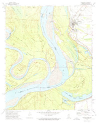
1972 Map of Rosedale
USGS Topo · Published 1974About this map
Rosedale sits at the nexus of river commerce and rail transport in the early 1970s, positioned between the Mississippi River and the Illinois Central Gulf railroad. The landscape is defined by the hydrologic history of the Delta, most notably the Beulah Crevasse (1912) and the sprawling Lake Beulah. This survey documents a complex system of levees, chutes, and bayous like Log Loader Chute and Knowlton Bayou, which dictated the location of landings such as Riverton Landing and Beulah Island Landing. Local genealogy is anchored by sites like Amos Tabernacle Cem and the Pleasant Green Ch. The map also captures the confluence of the Arkansas River and the Mississippi, highlighting the shifting boundaries and massive landforms like Big Island and Beulah Island that shaped the region's agricultural and social layout.
Find a feature on this map
50 named features on this map. Tap any name to fly to it.
Don’t see what you’re looking for? This feature index may not catch every label — zoom into the map to look around manually.
Map Details
Editions of this 1972 Rosedale Map
This is the sole edition of this map. No revisions or reprints were ever made.
Other maps of this area

1933 · Lamont
USGS Topo · 1:62,500

1939 · Pace
USGS Topo · 1:62,500

1939 · Big Island
USGS Topo · 1:62,500

1939 · Lamont
USGS Topo · 1:62,500

1939 · Choctaw
USGS Topo · 1:62,500

1953 · Greenwood
USGS Topo · 1:250,000

1956 · Greenwood
USGS Topo · 1:250,000

1967 · Lobdell
USGS Topo · 1:24,000
1969 · Choctaw
USGS Topo · 1:62,500
1969 · Beulah
USGS Topo · 1:24,000