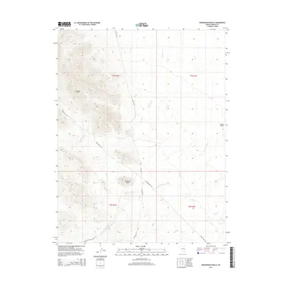
2014 Map of Rosencrans Knolls
USGS Topo · Published 2014About this map
Limestone Hills rise sharply above the high desert floor in this Lincoln County landscape, defining the western portion of a terrain shaped by drainage and ranching access. The arid flats of Hamlin Valley sit to the east, while the central Rosencrans Knolls provide a series of modest elevations between the more prominent ranges. Water management is evident through the naming of W Ditch and E Ditch, suggesting early efforts to direct seasonal flow through this basin. Transportation in the area relies on a network of unpaved tracks, including the curiously named Bloodstain Rd and the long stretch of Johnson Ranch Rd, which connects remote parcels. Seasonal waterways like Rosencrans Cr and Wood-McCullough Cr carve shallow paths across the valley, marking the natural drainage patterns that have historically dictated the placement of local wells and ranching infrastructure.
Find a feature on this map
16 named features on this map. Tap any name to fly to it.
Don’t see what you’re looking for? This feature index may not catch every label — zoom into the map to look around manually.
Map Details
Editions of this 2014 Rosencrans Knolls Map
This is the sole edition of this map. No revisions or reprints were ever made.
Other maps of this area

1956 · Lund
USGS Topo · 1:250,000

1960 · Lund
USGS Topo · 1:250,000

1972 · Gleason Basin
USGS Topo · 1:24,000

1972 · Rosencrans Knolls
USGS Topo · 1:24,000

1972 · Hamlin Well
USGS Topo · 1:24,000

1972 · Miller Wash
USGS Topo · 1:24,000

1972 · Hyde Well
USGS Topo · 1:24,000

1972 · Miller Canyon
USGS Topo · 1:24,000

1973 · Atlanta
USGS Topo · 1:24,000
1973 · Trail Canyon
USGS Topo · 1:24,000