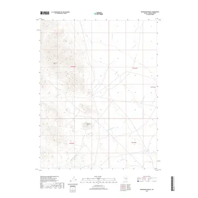
2018 Map of Rosencrans Knolls
USGS Topo · Published 2018About this map
Limestone Hills rise abruptly in the western portion of this Lincoln County survey, providing a stark topographical contrast to the more level terrain of Hamlin Valley to the east. The landscape is defined by its drainages, including the branching paths of Rosencrans Cr and Wood McCullough Cr, which flow toward the lower basin. Human modification of the arid environment is evident through irrigation and water management features such as West Ditch, East Ditch, and the specifically labeled West-pitch. Centrally located, the namesake Rosencrans Knolls stand as a distinct landform among the intersecting creek beds. The map details the Township and Range system across T7N and T6N, illustrating how early land divisions organized this corner of the Great Basin.
Find a feature on this map
13 named features on this map. Tap any name to fly to it.
Don’t see what you’re looking for? This feature index may not catch every label — zoom into the map to look around manually.
Map Details
Editions of this 2018 Rosencrans Knolls Map
This is the sole edition of this map. No revisions or reprints were ever made.
Other maps of this area

1956 · Lund
USGS Topo · 1:250,000

1960 · Lund
USGS Topo · 1:250,000

1972 · Gleason Basin
USGS Topo · 1:24,000

1972 · Rosencrans Knolls
USGS Topo · 1:24,000

1972 · Hamlin Well
USGS Topo · 1:24,000

1972 · Miller Wash
USGS Topo · 1:24,000

1972 · Hyde Well
USGS Topo · 1:24,000

1972 · Miller Canyon
USGS Topo · 1:24,000

1973 · Atlanta
USGS Topo · 1:24,000
1973 · Trail Canyon
USGS Topo · 1:24,000