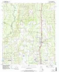
1994 Map of Rosepine
USGS Topo · Published 1997About this map
Rosepine sits at the heart of this Louisiana landscape, where the northern edge of Deridder begins to emerge along the southern boundary. This 1994 update reveals the intersection of industrial land use and the natural drainage systems of the West Louisiana piney woods. To the west, the Anacoco River winds through the bottomlands, fed by numerous tributaries including Pocosin Creek, Big Creek, and Nichols Creek. The transition from rural forest to developed areas is evidenced by the presence of Gravel Pits and the specialized Minnow Ponds near the center of the sheet. Further south, the settlement of Ludington stands near the Vernon Parish and Beauregard Parish line, a boundary that bisects the map and marks the shift between these two regional jurisdictions. The intricate network of waterways like Little Clear Creek and Flat Creek suggests a landscape historically defined by its timber and water resources.
Find a feature on this map
23 named features on this map. Tap any name to fly to it.
Don’t see what you’re looking for? This feature index may not catch every label — zoom into the map to look around manually.
Map Details
Editions of this 1994 Rosepine Map
This is the sole edition of this map. No revisions or reprints were ever made.
Other maps of this area

1941 · Leesville
USGS Topo · 1:62,500

1941 · Slagle
USGS Topo · 1:62,500

1943 · Leesville
USGS Topo · 1:62,500

1944 · Slagle
USGS Topo · 1:62,500

1946 · Leesville
USGS Topo · 1:62,500

1947 · Pujo
USGS Topo · 1:31,680

1947 · DeRidder
USGS Topo · 1:31,680

1947 · Rosepine
USGS Topo · 1:31,680

1947 · Knight
USGS Topo · 1:31,680

1947 · Ikes
USGS Topo · 1:31,680