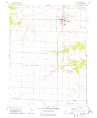
1974 Map of Roseville
USGS Topo · Published 1978About this map
Roseville serves as the primary hub in this mid-1970s western Illinois landscape, situated at a key intersection of regional commerce and transport. The Burlington Northern railroad runs north-to-south through the center of town, passing the local High Sch and a Sewage Disposal Pond. Beyond the residential blocks of Roseville, the map reveals a rural expanse defined by townships like Ellison, Point Pleasant, and Swan.
Find a feature on this map
27 named features on this map. Tap any name to fly to it.
Don’t see what you’re looking for? This feature index may not catch every label — zoom into the map to look around manually.
Map Details
Editions of this 1974 Roseville Map
This is the sole edition of this map. No revisions or reprints were ever made.
Other maps of this area

1916 · Good Hope
USGS Topo · 1:62,500

1918 · La Harpe
USGS Topo · 1:62,500

1918 · Good Hope
USGS Topo · 1:62,500

1921 · Monmouth
USGS Topo · 1:62,500

1923 · Monmouth
USGS Topo · 1:62,500

1934 · Oquawka
USGS Topo · 1:48,000

1940 · Oquawka
USGS Topo · 1:62,500

1958 · Burlington
USGS Topo · 1:250,000

1961 · Burlington
USGS Topo · 1:250,000

1963 · Burlington
USGS Topo · 1:250,000