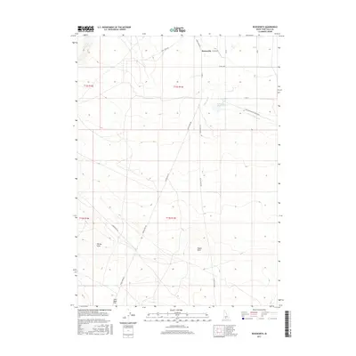
2017 Map of Roseworth
USGS Topo · Published 2017About this map
Roseworth and the surrounding high desert of Twin Falls County are defined by a sophisticated network of irrigation that transforms the arid landscape. The Cedar Mesa Reservoir serves as a central hub for this water management system, feeding the Cedar Mesa Canal and the Clark Lateral to support local agricultural efforts. This 2017 survey illustrates the intersection of modern resource management with classic western topography, featuring prominent landmarks such as Pigtail Butte and the distinctive Coonskin Butte. To the west, the terrain is cut by drainage features like Devil Cr and Worley Draw, while named locales like John Boyd Flat suggest a history of grazing or early land claims. The road network, including the Antelope Springs Roseworth route, provides essential access across the gridded sections of the Public Land Survey System.
Find a feature on this map
23 named features on this map. Tap any name to fly to it.
Don’t see what you’re looking for? This feature index may not catch every label — zoom into the map to look around manually.
Map Details
Editions of this 2017 Roseworth Map
This is the sole edition of this map. No revisions or reprints were ever made.
Other maps of this area

1955 · Twin Falls
USGS Topo · 1:250,000

1958 · Twin Falls
USGS Topo · 1:250,000

1964 · Roseworth
USGS Topo · 1:24,000

1965 · Roseworth SE
USGS Topo · 1:24,000

1965 · Roseworth NE
USGS Topo · 1:24,000

1965 · Tuanna Butte
USGS Topo · 1:24,000

1977 · Cedar Creek Reservoir
USGS Topo · 1:24,000

1978 · Browns Bench North
USGS Topo · 1:24,000

1979 · Coonskin Butte NE
USGS Topo · 1:24,000
1979 · Roseworth NE
USGS Topo · 1:24,000